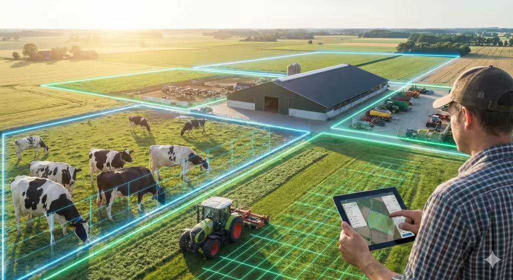
Welcome to the new age of farming. If you grew up in a rural area with farming you know that a fence is more than just wire and wood. It is a promise. It is the boundary that keeps your livelihood safe and your livestock where they belong. But as we move further into 2026, those physical lines are getting a digital upgrade. As specialists at WebHeads United, we spend our days looking at the intersection of geography and technology. Today, we want to talk to you about one of the most powerful tools in our belt: geofencing for farms.
When we talk about geofencing for farms, we aren’t just talking about fancy gadgets for the sake of having them. We are talking about a major shift in how you manage your land. Imagine being able to draw a line on a tablet screen and having your cattle stay within that line without a single post being driven into the ground. Or imagine getting a text message the moment your expensive tractor leaves your barn in the middle of the night. That is the reality of geofencing for farms today. It combines GPS, cellular data, and a bit of computer science to create a “virtual fence” that works 24 hours a day.
In this guide, we are going to break down why geofencing for farms is a game-changer for small and large operations alike. We will look at how it keeps your animals safe, how it protects your gear, and even how it helps you save money on water and chemicals. Whether you are a tech expert or someone who just wants to keep their cows out of the neighbor’s corn, there is a lot to learn about geofencing for farms.
What Exactly is Geofencing for Farms?

When we peel back the layers of a modern agricultural operation, we see that the most valuable thing a farmer owns, besides the land itself, is the information about that land. To understand what exactly geofencing for farms is, you have to think of it as a digital layer that sits right on top of your physical dirt.
In my work at WebHeads United, I often tell clients that a geofence is a “locational trigger.” At its simplest level, geofencing for farms is a technology that uses the Global Positioning System (GPS) or Radio Frequency Identification (RFID) to create a virtual boundary around a specific geographic area. Once that boundary is drawn on a digital map, the software monitors the location of “tags”—which could be a collar on a prize bull, a tracker on a grain truck, or even a smartphone in a worker’s pocket.
How the Technology Creates the Boundary
To make geofencing for farms work, we rely on a network of satellites orbiting the Earth. These satellites send signals down to receivers on your equipment. In 2026, these receivers have become incredibly small and efficient. When you use an app to draw a circle or a complex polygon around your north pasture, you are essentially telling the computer: “These specific latitude and longitude coordinates are now a ‘hot zone’.”
This “hot zone” stays dormant until an object with a receiver crosses that line. That is when the magic happens. The system recognizes the crossing in real-time. Because I value data integrity, it is important to note that the accuracy of geofencing for farms has improved drastically. In the past, a “drift” of ten or twenty feet was common. Today, especially with the 2026 updates to our national coordinate systems, we can get that accuracy down to just a few inches. This means your virtual fence is often more precise than a sagging barbed-wire line.
The Different Types of Geofences
Not all digital fences are the same. When setting up geofencing for farms, you usually choose between two main types:
-
Static Geofences: These are permanent boundaries. You might set these around your property lines, your farm house, or your permanent storage sheds. Once they are set, they don’t move. They are great for long-term security and knowing if equipment is staying where it belongs.
-
Dynamic or Mobile Geofences: This is where the computer science side of my brain gets excited. A mobile geofence can move. For example, you can set a “buffer zone” around a moving pesticide sprayer. If a person or a different vehicle enters that moving bubble, the system can send an alert or even shut the sprayer down to prevent an accident.
Why the “Trigger” Matters
The “fence” part of geofencing for farms is only half the story. The real power is in the “trigger.” A trigger is the action that happens when the boundary is crossed. For a small business owner, these triggers are what save you time and money.
A trigger can be an “Entry Alert,” which tells you when a delivery truck has arrived at the gate. It can be an “Exit Alert,” which warns you if a tractor is being driven away by someone who shouldn’t have it. In more advanced geofencing for farms setups, the trigger can even be a “Dwell Time” alert. This tells you if a piece of machinery has been sitting idle in one spot for too long, which might mean a worker is stuck or the machine has broken down in the field.
The 2026 Precision Standard
I live in Redlands, which is a major center for mapping technology, so I see these changes first-hand. In 2026, geofencing for farms has moved away from the old, shaky GPS of ten years ago. We are now using “Multi-GNSS,” which means your devices aren’t just talking to American satellites, but also to European and Gallileo systems.
This increased “spatial awareness” is what makes geofencing for farms a professional-grade tool rather than a hobbyist toy. For a farmer, this means you can trust that when the system says a cow is in the clover, she is actually in the clover. We are no longer guessing; we are measuring with scientific certainty.
By understanding these technical foundations, you can see that geofencing for farms is essentially a bridge between your physical land and your digital management tools. It takes the guesswork out of where your assets are, allowing you to run your farm with the precision of a doctor and the efficiency of a CEO.
Livestock Management and Virtual Fencing

One of the biggest wins for geofencing for farms is in the world of livestock. Traditional fencing is expensive. It takes hours of hard labor to build, and even more to fix when a tree falls or a bull gets a wild idea. With virtual fencing, you can manage your herd from your kitchen table.
By using geofencing for farms, you can set up “smart grazing” zones. This means you can move your cows to a fresh patch of grass every few days just by moving the lines on your map. This keeps the soil healthy and ensures your animals always have the best food. If a cow tries to cross the line, her collar will give a warning. It is a kind and effective way to manage a large herd without miles of wire.
Protecting Your Assets and Stopping Theft
Let’s talk about the gear. A modern tractor or combine costs more than some houses. Unfortunately, they are also targets for thieves. Geofencing for farms gives you an invisible security guard. You can set a geofence around your equipment shed. If that tractor starts moving at 2:00 AM when it should be parked, you will know instantly.
This use of geofencing for farms is not just about theft, though. It also helps with maintenance. You can track how long a machine stays in a certain field. This data tells you exactly how many hours it worked. When you know the exact time a machine spent working, you can plan your oil changes and repairs better. This keeps your machines running longer and prevents break-downs during the busy harvest season.
Precision Crop Management and Better Spraying

Now, let’s talk about the heart of the farm: the crops. This is where the technical side of geofencing for farms really shines. Precision agriculture is all about doing the right thing, in the right place, at the right time. When you use geofencing for farms for crop management, you are taking the guesswork out of your fieldwork.
Section Control and Overlap Prevention
When you drive a large sprayer through a field, it is very hard to keep your lines perfectly straight. Even the best drivers will often spray the same area twice at the edge of a field or where the rows are at an angle. This is a waste of expensive chemicals and can actually hurt your crops.
With geofencing for farms, your sprayer is “aware” of where it has already been. The system uses the digital boundary of the field to know exactly where to spray. As the machine moves into an area that was already covered, the geofencing for farms software tells the sprayer to shut off individual sections of the boom. This is called “section control.” It ensures that every inch of your field gets exactly one dose of chemical—no more and no less.
Protecting Sensitive Areas
Many farms have areas that should never be sprayed. This might be a creek, a pond, a neighbor’s organic garden, or a beehive. In the past, you had to be very careful to turn off your sprayer manually. With geofencing for farms, you can draw a “no-spray zone” around these sensitive spots.
As your tractor gets close to the creek, the geofencing for farms system will automatically lock out the sprayer. Even if the driver forgets, the computer will not. This protects the environment and keeps you out of trouble with the law. It is one of the most responsible ways to use geofencing for farms on a modern homestead or commercial operation.
Variable Rate Application
Not every part of a field is the same. Some spots might have better soil, while others might be rocky or dry. In 2026, we use geofencing for farms to create “prescription maps.” You can tell your machine to drop more fertilizer in the high-quality soil and less in the rocky areas.
This use of geofencing for farms is called Variable Rate Application. By dividing your field into many small geofences, you can treat each patch of dirt like its own little farm. This saves a massive amount of money on inputs. When you stop treating the whole field as one big block and start using geofencing for farms to manage the small details, your profit margins go up.
Improving Traceability and Record Keeping
In 2026, people want to know how their food was grown. They want to know exactly what was sprayed on their vegetables. Geofencing for farms makes this easy. Every time your sprayer moves through a field, the system records the exact path and the exact amount of product used.
This creates a digital “paper trail.” If a buyer asks for proof of your farming practices, you can simply pull up the report from your geofencing for farms software. It proves that you stayed within your boundaries and followed the rules. This data integrity is a core value for me, and it should be for any small business owner who wants to build trust with their customers.
The 2026 Precision Edge
The accuracy we have today is thanks to the 2026 GPS update. We are now using a new system called NATRF2022. This shift has fixed many of the old errors in our maps. When you use geofencing for farms today, the lines stay exactly where you put them. They don’t drift like they used to.
For precision spraying, this is vital. If your virtual fence drifts by five feet, you might end up spraying your neighbor’s property or missing a row of your own crops. But with the 2026 standards, geofencing for farms is more reliable than ever. It allows you to operate with sub-inch accuracy. That level of precision is what makes geofencing for farms the ultimate tool for crop management.
Saving Water with Smart Irrigation
Water is becoming more precious every year. Geofencing for farms is a key part of “smart irrigation.” Many farms use big pivots that move in a circle to water the crops. With geofencing, you can program that pivot to change how much water it drops based on where it is.
If one part of your field is sandy and dries out fast, the geofencing for farms system tells the pivot to slow down and give more water. If another part is a low spot that stays wet, it can speed up or turn off. This targeted approach means you don’t over-water or under-water. It creates a more even crop and lowers your electric bill for the pumps.
Managing Labor and Workflows
Running a farm is a team effort. You might have several workers in different fields at once. Geofencing for farms makes it easy to see where everyone is and what they are doing. This isn’t about “spying” on people; it’s about safety and efficiency.
If a worker is out in a remote field and their vehicle hasn’t moved for an hour, geofencing for farms can flag that. You can check in to make sure they are okay. It also helps with payroll. You can see exactly when a crew entered a specific orchard and when they left. This makes it much easier to keep accurate records and pay people fairly for the work they do.
The 2026 GPS Shift: What You Need to Know
One thing a lot of geographers are all talking about right now is the 2026 datum shift. This is a technical change in how GPS works across the country.
The old way of measuring coordinates is being replaced by a more accurate system called NATRF2022. If you are using geofencing for farms, your old digital lines might “drift” by a few feet this year. As an expert in GIS, I suggest that all small business owners and farmers check their settings. You may need to redraw your lines to make sure they still match up with your real-world fences. This is a one-time update that will make geofencing for farms even more precise for years to come.
Common Questions About Geofencing for Farms
People often ask, “Is this too expensive for a small farm?” The answer is usually no. While the big systems used by massive corporations cost a lot, there are many affordable options for small businesses. You can start with simple trackers on your most expensive gear.
Another big question is about cell service. “What if I don’t have bars out in the back pasture?” In 2026, we have a lot of options. Many geofencing for farms systems now use satellite links or “LoRaWAN” networks. These can send signals over long distances even without a cell tower nearby. This means geofencing for farms is now an option for almost everyone, no matter how remote your land is.
The Value of Data Integrity
Geofencing for farms is only as good as the data you put into it. When you set up your system, take the time to map your boundaries carefully. Use a high-quality GPS receiver to mark your corners.
When you have good data, you have “data integrity.” This means you can trust your system. You can sleep better knowing that the alerts you get from your geofencing for farms app are real. In the long run, this trust is what allows you to focus on the other parts of your job, like tending to your crops and planning for next year.
How to Get Started with Geofencing for Farms
If you are ready to try this out, start small. Pick one problem you want to solve. Is it keeping track of your tractor? Is it managing one small herd of goats? Buy a few trackers and see how the software works.
Most geofencing for farms programs are very user-friendly. They look like the maps on your phone. You just tap and drag to create your zones. Once you see the benefits of geofencing for farms in action, you can expand to other parts of your operation.
Final Thoughts on the Future of Farming
The world is changing, but the core values of farming stay the same. You want to work hard, be honest, and take care of what you have. Geofencing for farms is just a new tool to help you do those things better. It reduces the stress of wondering where your cows are or if your equipment is safe.
By using geofencing for farms, you are moving your business into the future. You are saving time, saving money, and protecting the land. As we navigate the technical shifts of 2026, we are here to help you make sense of it all. Precision and geography are the keys to a successful farm in this digital age.