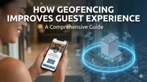
A Definitive Comparison: GPS vs. Beacon for Geofence Accuracy
The distinction between a timely, value-adding customer engagement and an unwelcome digital interruption often measures just a few meters. When you are trying to polish your location-based marketing, this small distance represents a significant strategic chasm. The efficacy of any such initiative is fundamentally tethered to the technological framework upon which it is built—a choice that dictates not only the precision of the interaction but also its context, cost, and impact on the user experience.
The two principal modalities in this domain, the Global Positioning System (GPS) and Bluetooth Low Energy (BLE) Beacons, are frequently discussed but often misunderstood as interchangeable tools. In reality, they represent fundamentally different approaches to answering the same basic question: “Where is my customer?” One operates on a planetary scale, conversing with satellites in orbit, while the other whispers to devices just feet away. This analysis aims to move beyond surface-level comparisons, providing a technical, data-driven examination of each technology. The objective is to empower businesses with the necessary insights for strategic implementation, ensuring that your investment in location-based technology yields the highest possible return through precision and relevance.
Foundational Concepts: Understanding the Core Technologies
Before a direct comparison can be conducted, a clear, technical understanding of the components is necessary. An architect does not compare a hammer and a screwdriver without first understanding their distinct mechanical functions. The same principle applies here.
What is a Geofence?

At its core, a geofence is a virtual perimeter for a real-world geographic area. The concept, rooted in the principles of geographic information systems (GIS), has evolved from a specialist tool to a cornerstone of modern mobile marketing. It is not a technology in itself, but rather a result produced by a location-determining technology.
Think of it as a digital tripwire. This boundary is defined within software, typically using coordinates on a map. Common shapes include a simple radius around a point (a circular geofence) or a more complex, custom-drawn shape (a polygonal geofence) that might trace the exact outline of a property lot or a specific building.
The mechanism is straightforward: a software development kit (SDK) integrated within a mobile application periodically checks the device’s location. When the device’s coordinates cross the pre-defined boundary, it triggers one of three primary events:
- On Enter: The device has just entered the geofenced area.
- On Exit: The device has just left the geofenced area.
- On Dwell: The device has remained within the geofenced area for a specified duration.
Upon triggering one of these events, a pre-programmed action is executed. This is most commonly a push notification, but it can also be an in-app content change, a data log for analytics, or an API call to a third-party system.
How GPS (Global Positioning System) Works for Geofencing
The Global Positioning System is a satellite-based radionavigation system owned by the United States government and operated by the United States Space Force. While its origins are military, it has become a ubiquitous global utility.
The technical basis for GPS is a process called trilateration. A constellation of approximately 31 operational satellites orbits the Earth, each broadcasting a continuous signal containing its precise location and the time the signal was sent. A GPS receiver in a smartphone must lock onto the signals from a minimum of four satellites to calculate a precise position.
- The receiver calculates its distance from the first satellite by measuring the time delay between when the signal was sent and when it was received. This places the receiver somewhere on the surface of a sphere with the satellite at its center.
- Receiving a signal from a second satellite creates a second sphere. The intersection of these two spheres forms a circle.
- A signal from a third satellite narrows the possible location down to two points on that circle.
- The fourth satellite is crucial. Its signal resolves the ambiguity between the two points and, importantly, allows the receiver to solve for the variable of time. The receiver’s clock is not as precise as the atomic clocks on the satellites, and this fourth signal corrects for the timing error, dramatically improving positional accuracy.
For geofencing, the smartphone’s operating system (iOS or Android) uses the on-board GPS chipset to determine its coordinates (). This location is then compared against the coordinates of the geofences registered by various apps. Due to various factors like atmospheric signal delay and multipath interference (signals bouncing off buildings), the practical accuracy for a consumer smartphone is typically within a 5 to 20-meter radius under open skies. This makes GPS the ideal tool for macro-level geofencing: city blocks, shopping centers, and large event venues.
How Beacons (BLE) Work for Proximity Marketing
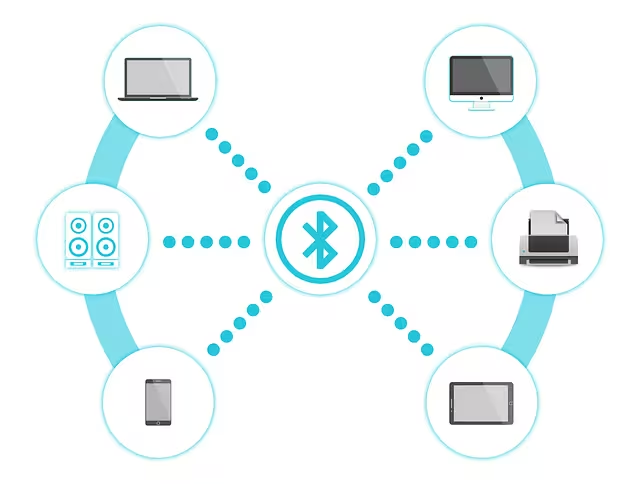
Beacons are not a replacement for GPS, but rather a solution for a problem GPS cannot solve: precise indoor micro-location. A beacon is a small, low-cost piece of hardware—a transmitter. It does not know where it is, nor does it track anything. Its sole function is to repeatedly broadcast a signal saying, “I am here, and my name is [unique ID].”
This broadcast uses the Bluetooth Low Energy (BLE) protocol, a highly power-efficient subset of standard Bluetooth. A smartphone with a corresponding app and Bluetooth enabled can “hear” these broadcasts. The app can then perform three actions:
- Identify the Beacon: It reads the beacon’s unique identifier. The two dominant protocols for this are Apple’s iBeacon, which broadcasts a simple UUID, Major, and Minor value, and Google’s Eddystone, which is more flexible and can broadcast URLs, telemetry data (like temperature), and other information packets.
- Estimate Proximity: The app measures the strength of the received signal, a value known as the Received Signal Strength Indicator (). A stronger signal generally implies closer proximity. By calibrating the beacon (measuring its at a known distance, e.g., 1 meter), the app can estimate its distance from the beacon. This is an estimation, not a precise measurement, as the signal can be absorbed or reflected by people, walls, and other objects.
- Trigger an Action: Based on the beacon’s ID and the estimated proximity (e.g., “immediate,” “near,” or “far”), the app can trigger a hyper-contextual action.
A beacon, therefore, doesn’t create a geofence in the traditional sense. It enables proximity detection, creating a “micro-fence” with a radius of centimeters to a few tens of meters. This is the technology that powers a notification about a specific shoe model when you are standing in that aisle of the store.
Head-to-Head Comparison: GPS vs. Beacon
With the foundational science established, we can now conduct a direct, feature-by-feature comparison. The following table provides a high-level summary, which will be followed by a detailed technical elaboration.
| Feature | GPS Geofencing | Beacon Proximity | Winner (Contextual) |
| Primary Environment | Outdoor | Indoor | Depends on Use Case |
| Accuracy | Low to Medium (5-20 meters) | High to Very High (sub-meter) | Beacons (for granularity) |
| Range | Global / Macro-level | Micro-level (up to 70 meters) | GPS (for scale) |
| Power Consumption | High (on user’s device) | Very Low (BLE protocol) | Beacons |
| Infrastructure Cost | None (uses phone hardware) | Per-unit hardware cost | GPS (for initial cost) |
| Setup & Maintenance | Software-based (map coordinates) | Physical installation & battery | GPS (for simplicity) |
| Signal Reliability | Susceptible to urban canyons, buildings | Susceptible to physical obstruction | Depends on Environment |
Detailed Breakdown of Comparison Points
Accuracy & Granularity

This is the most critical distinction. GPS accuracy is fundamentally limited by its architecture. Signals traveling 20,000 km from space are subject to atmospheric distortions and, most critically, signal attenuation. They are easily blocked by solid structures like roofs, concrete walls, and metal, which is why GPS performance degrades severely indoors. An accuracy of 5 meters, while impressive for outdoor navigation, is insufficient for distinguishing whether a customer is looking at televisions or refrigerators.
Beacons, conversely, are built for granularity. Because their BLE signal only needs to travel a short distance, its strength () can be used to classify proximity into zones—for instance, “immediate” (a few centimeters), “near” (a few meters), and “far” (up to 70 meters, depending on the beacon’s power). This allows for “aisle-level” or even “product-level” marketing. Think of GPS as a wide-net fishing operation, capable of determining which part of the lake the fish are in. Beacons are the equivalent of fly-fishing, targeting a specific fish in a specific pool.
Cost & Scalability

From an initial infrastructure perspective, GPS appears to be free. The satellites are maintained by the U.S. government, and the receiver is already present in the user’s smartphone. The primary cost is in the software—the platform used to manage geofences and the potential usage fees for mapping APIs (e.g., Google Maps API) if an application exceeds the free tier of service calls.
Beacons introduce a direct hardware cost. Individual units can range from $5 to $30, and a retail space may require dozens to provide comprehensive coverage. This upfront capital expenditure must be factored into any ROI calculation. However, this cost must be weighed against the potential for higher conversion rates from hyper-targeted offers that beacons enable. The scalability of a beacon deployment is limited by budget and the physical effort of installation, whereas GPS geofences can be created and scaled infinitely within a software dashboard.
User Experience & Battery Life

This is a silent but deadly factor in application success. To provide real-time geofence triggers, an application must request location updates from the operating system. High-accuracy GPS polling is one of the most power-intensive operations a smartphone can perform. Continuous tracking can drain a standard battery in a matter of hours, leading to a poor user experience and a high probability of the user revoking location permissions or uninstalling the app altogether. Modern operating systems have implemented efficiencies, but the drain remains significant.
Bluetooth Low Energy was designed from the ground up for minimal power consumption. A phone’s BLE radio can scan for beacon signals in short, efficient bursts, having a nearly negligible impact on battery life over a 24-hour period. For any application that requires persistent location awareness, BLE is the demonstrably superior choice for maintaining user trust and app retention.
Practical Use Cases for Small Businesses
The theoretical differences become clear when grounded in real-world business scenarios.
When to Use GPS Geofencing:

The strength of GPS is its scale. It excels when the target area is large and the required action is not dependent on pinpoint precision.
- Curb-side Pickup & Logistics: A restaurant application can create a 500-meter geofence around its location. When a customer who has placed an order enters this zone, the system can send an alert to the kitchen to “fire” the order, ensuring it’s hot and ready the moment the customer arrives.
- Broad-Area Promotions: A car wash can set a 2-mile geofence. On a sunny Saturday, it can trigger a push notification to all app users within that zone: “Perfect day for a wash! Show this message for $5 off our Ultimate Shine package.”
- Competitor Conquesting: A local hardware store can place a geofence around a nearby big-box competitor. When one of their app users enters the competitor’s geofence, they can trigger a targeted offer: “Shopping for tools? We offer a lifetime warranty on all our house-brand hand tools. Just 5 minutes away!”
- Event Marketing: The organizer of a local music festival can geofence the entire fairground. As attendees enter, they can receive a welcome message with a link to the day’s schedule and a map of the venue.
When to Use Beacon Technology:

Beacons thrive on context and immediacy, transforming a physical space into an interactive environment.
- In-Store Navigation & Product Information: A large bookstore can place beacons in each section. As a user enters the “History” section, the store’s app could highlight new releases in that category. Standing in front of a specific display for more than 30 seconds could trigger a notification with author interviews or customer reviews.
- Museum & Gallery Guides: This is a classic use case. A visitor approaches Monet’s “Water Lilies.” As they come within two meters, their phone buzzes. The museum app opens to a page with a high-resolution image, the curator’s notes on the piece, and an audio clip discussing Monet’s technique. This level of contextual engagement is impossible with GPS.
- Automated Loyalty & Check-ins: A coffee shop can place a beacon near its entrance. When a loyalty member enters, the app can automatically check them in, perhaps even greeting them by name on a digital display and applying their standard order to the point-of-sale system, creating a seamless, personalized experience.
- Interactive Experiences: A real estate agent can place beacons in different rooms of a house for sale. As prospective buyers walk through, the app can display information about room dimensions, renovation details, or staging information, providing a self-guided tour.
Commonly Asked Questions
In my work, I encounter the same set of valid questions repeatedly. Addressing them directly is the most efficient path to clarity.
What is the real difference between a geofence and a beacon?
This is the most common point of confusion. The most effective analogy is this: a geofence is the question (“Is the user in this defined area?”). The technology—be it GPS, a beacon, Wi-Fi, or cell towers—is the method used to get the answer. A GPS geofence is a boundary drawn in software on a map. A beacon enables a micro-fence defined by the hardware’s signal range. You use GPS to define a large area; you use a beacon to define a hyper-local point of interest.
How accurate can geofencing truly be?
Accuracy is relative to the technology used. GPS-based geofencing accuracy is reliably in the 5 to 20-meter range in optimal, outdoor conditions. This can be affected by weather, tall buildings (the “urban canyon” effect), and the quality of the device’s GPS chipset. For a beacon, “accuracy” is better described as “proximity resolution.” It can reliably determine if a device is within centimeters, a few feet, or several meters away. Its precision is affected by physical obstructions (people, walls, metal shelving) that can weaken or block the BLE signal.
Can geofencing be done without GPS?
Yes. While GPS is the most common method for large-scale outdoor geofencing, it is not the only one.
- Wi-Fi Positioning: Operating systems can determine a device’s location based on the known locations of nearby Wi-Fi networks. The accuracy is highly variable, from 10 to 50 meters, but it consumes less power than GPS and works better indoors.
- Cell Tower Triangulation: A device’s location can be estimated by its proximity to multiple cell towers. This is the least accurate method (often 100-1000 meters) but is also the most power-efficient, as the phone is always communicating with cell towers.
- Beacons: As detailed above, beacons are the primary method for high-precision indoor proximity detection, effectively creating micro-geofences without relying on GPS at all.
Is beacon technology still relevant in 2025?
As of August 2025, beacon technology has matured past its initial hype cycle and settled into its role as a powerful, specialized tool. Early, broad predictions of beacons being on every street corner were unrealistic. However, its relevance has actually increased in specific verticals where the physical, in-person experience is paramount. In retail, hospitality, event management, and corporate logistics, beacons are a proven and effective technology for driving engagement, improving efficiency, and gathering granular analytics that are otherwise unattainable. They are a key component of the Internet of Things (IoT) ecosystem, providing the crucial location context for smart devices.
Our Recommendation: A Decision Framework for Your Business
Choosing between these technologies is a strategic decision, not just a technical one. Before committing resources, conduct the following “Pre-Implementation Audit” by answering these four questions:
- What is my Engagement Environment? Is your primary point of interaction outdoors (e.g., a parking lot, a general neighborhood) or indoors (e.g., inside your store, a conference hall)? If it’s outdoor and macro-level, GPS is your starting point. If it’s indoor and micro-level, beacons are the only viable solution for high accuracy.
- What is my Required Precision? Do you need to know if a customer is within a one-mile radius, or do you need to know if they are standing in front of Aisle 4B? The required granularity of your marketing action will dictate the necessary precision of the technology.
- What is our Tolerance for Cost vs. User Experience? Is your budget more sensitive to upfront hardware costs (Beacons), or is your application’s success more sensitive to potential user churn from battery drain (GPS)? A high-value application might justify the hardware cost of beacons to preserve a pristine user experience.
- What is the Ultimate User Action? Define the specific goal. Is it to draw a customer from the general area to your store? That’s a job for GPS. Is it to help a customer inside your store make a better purchase decision? That is a job for a beacon.
Conclusion
The comparison of GPS and Beacons is not a matter of determining a “winner.” It is an exercise in selecting the correct instrument for a specific task. To summarize the core trade-off: GPS offers immense scale and reach for outdoor, macro-level engagement at the cost of precision and battery life. Beacons provide surgical precision and contextual relevance for indoor, micro-level interactions at the cost of hardware and physical installation.
The most sophisticated location-based strategies often employ a hybrid approach, using GPS to bring a customer to the door and beacons to enrich their experience once inside. The best technology is the one that aligns seamlessly with your specific customer journey and business objectives. Do not think of it as a competition, but as a toolbox. A master craftsman knows when to use a sledgehammer and when to use a scalpel.
Geofencing technology offers powerful tools, but implementation requires expertise. If you’re ready to leverage location-based marketing with precision and a clear strategy, contact the team at WebHeads United LLP for a consultation.